
CINFÃES
N 41.07460º; W 8.09080º
Cinfães is a Portuguese village located in the sub-region of Tâmega and Sousa, belonging to the North region and the district of Viseu.
It is the seat of the Municipality of Cinfães, which has a total area of 239.29 km2, 17,730 inhabitants in 2021 and a population density of 74 inhabitants per km2, subdivided into 14 parishes. The municipality is limited to the north by the municipalities of Marco de Canaveses and Baião, to the east by Resende, to the south by Castro Daire and Arouca and to the west by Castelo de Paiva.
Its history is linked to the Knights Templar, who owned fortresses here, such as Torre da Chã or Torre dos Pintos; and also the story of the childhood of the King D. Afonso Henriques and his aio Egas Moniz.
It has an important built heritage, highlighting the Romanesque churches, such as the Church of São Cristóvão de Nogueira; the Church of Our Lady of Cales or Cádiz, among many others.
History
With roots in prehistory, the population evidence of Cinfães is based on the pre-Celtic Paleolithic period (the age of chipped stone), with nomadic peoples of African origin: Capsenses and Berbers, who spread across Iberia and left traces of value in the municipality area. In the 9th and 8th centuries BC, the first Celtic occupation takes place, from whose mixture with settled peoples, the Lusitanians of the Iron Age result, who move to the mountains in order to settle in strategic positions of protection from constant invasions.
It is on these slopes of the municipality that, even today, there are numerous secular castros of megalithic origin.
In the 6th century BC, with the Douro River as a commercial route to the Greek market, the Hispanics arrived who, due to the commercial advantage of the river, quickly lost their territory to the Romans. It was during this phase that the first settlements grew in the form of towns and cities, all interconnected by medieval roads and bridges that are still in good condition in the municipality.
It is in the year 409 AD, that the new barbarians, Swabians, Alans and Vandals appear, and in 456, they start the wars with the Visigoths, whose objective is the taking of the Iberian territory.
Hydrographic Network
The municipality of Cinfães is crossed by several water courses. Coming from the Serra da Lapa, the Paiva River flows in a meandering valley. To the east we have the Cabrum River, with NWW/SSE orientation, suffering a small detour to the North, already in the final part of its valley. It rises near the Montemuro mountain range and flows into the Douro river, in the Oliveira do Douro region. Almost perpendicular to the Douro River and with a rectilinear layout, oriented along the NNW -SSE course, runs the Bestança River, the largest river exclusively in Cinfanna.

The watercourses, thanks to the humid climate that the condensation barrier of the Serra de Montemuro provides, have water throughout the year. The fact that the riverbeds are, for the most part, quite inclined, gives them a torrential regime, particularly in the wettest season, with their flows being lower in the summer.
It is a dense hydrographic network, with a rigid layout, where two directions predominate (NNE/SSW and NW/SE). It should also be noted the hydroelectric use of some of these courses, namely the Cabrum River and the Douro River, where one of its most imposing dams is built - the Carrapatelo Dam.
It is a dense hydrographic network, with a rigid layout, where two directions predominate (NNE/SSW and NW/SE). It should also be noted the hydroelectric use of some of these courses, namely the Cabrum River and the Douro River, where one of its most imposing dams is built - the Carrapatelo Dam.
Climate
Due to the high variation in altitude, the municipality of Cinfães presents strong thermal and rainfall contrasts between the Douro valley and the top of the Serra de Montemuro. The climate on the left bank of the Douro River valley is, in general, temperate: it varies constantly between 0 °C. at the edge of winter and 30 °C. in summer, being moderate in the autumn and spring seasons. The Montemuro mountain chain, with rigorous winters of negative temperatures, shows an annual average of 12.5 °C. with moderate winds in all seasons. Due to the amount of water absorbed during the winter and rainy seasons, the climate is generally humid.
Parishes
The municipality of Cinfães is divided into 14 parishes:Alhões, Bustelo, Gralheira e Ramires
Cinfães
Espadanedo
Ferreiros de Tendais
Fornelos
Moimenta
Nespereira
Oliveira do Douro
Santiago de Piães
São Cristóvão de Nogueira
Souselo
Tarouquela
Tendais
Travanca
Economy
The Municipality of Cinfães, with a rural and artisanal origin, is far from a productive value chain, presenting low values of labor available for the production of goods and services that enhance the economic circuit.
Recently, the tourist segment has emerged as a business opportunity, namely in terms of gastronomy and wines, nature tourism (Serra de Montemuro and Vale do Bestança) and nautical tourism (Douro River).

Of the 308 municipalities in the country, the inhabitants of Cinfães are the ones with the lowest purchasing power at national level.
Tourist Information
Serra de Montemuro offers the unique welcome of cultural and typically mountain villages, such as Vale de Papas, Bustelo da Lage, Aveloso and Gralheira.


😍😍😍
Bestança Valley
The Bestança river valley rises in the Serra de Montemuro, next to Portas de Montemuro, at an altitude of around 1,230 metres. This mountainous area is characterized by its rugged terrain, essentially granite in nature, defining the Bestança valley as deep and embedded. Following the Southeast/Northwest direction (SSE/NNV) up to the Douro River, this narrow and almost straight valley has steep slopes in the order of 300-400 meters, in a total length of approximately 15km, always in the municipality of Cinfães.
Extension 1.5 km
Initial coordinate 41° 2' 9.15" N; 8° 3' 7.27" W
How to get?
The Vale do Bestança Biodiversity Station starts in Valverde, a village right next to Cinfães, and ends at the bottom of the valley, on the Prado property.
Brief description
The route belonging to SIC Montemuro follows the descent of the valley to the Bestança river, one of the few Portuguese rivers without any human intervention in its water course. The Bestança rises in the Serra de Montemuro and is 13.5 km long before flowing into the Douro River. Along the valley we can appreciate the well-developed riverside vegetation, mixed with patches of oak, ending in an area of meadows and pastures. The last panels are located next to the “Prado” property, owned by the Associação de Defesa do Vale do Bestança, created to protect and conserve this sensitive ecosystem.

The valley is crossed by a circular trail, signposted along the entire itinerary and which extends for almost 19 kilometres.The route takes you along pleasant rural paths, along which vines appear, interrupting the woods. From time to time we can glimpse splendid landscapes over the Bestança valley.
The native vegetation appears in abundance along the trail. Chestnut trees, oaks and alders embellish the woods we pass through. The bridges over the river are another of the attractions of this wonderful route.


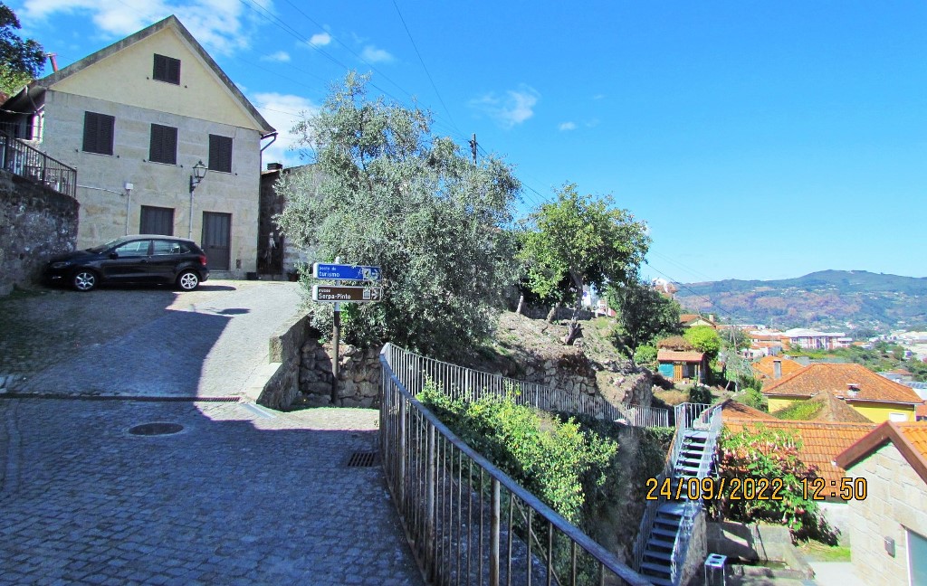
PIAS (CINFÃES)
41º 04´ N; 8º 04´ W
The village of Pias (from the common name "pia", rupestrian or dug in the rock; the settlement is due to clearing in the place) is a village in the parish and municipality of Cinfães, located in a valley between 150 and 200 meters in altitude on the bank left of one of the cleanest rivers in Europe, the Bestança River, and south of the Douro River.
History
The proximity of the river and the fact that a bridge was built in the Middle Ages, determined the prosperity of the village, as agriculture has always been the main activity of the locality.
Pias would have been an important and attractive town for all social classes, as can be seen from the existence of some important manor houses, alongside which some notable examples of genuine popular architecture nestle.
Patrimony
Of the built heritage, the following stand out:
Picturesque streets of granite flagstones, examples of genuine popular architecture and manor houses;
Water flow that crosses the entire village, Calçada, Sundial and Alminhas;
Chapel of Nossa Senhora do Sagrado Coração de Jesus and Chapel of São Gonçalo;
Pias Bridge, Pias Leisure Park and Bestança River, Mills and Bestança Valley Environmental Interpretation Center.

💛💛💛
PARISHES AND VILLAGES OF CINFÃES


OLIVEIRA DO DOURO
41° 05' 16" N; 8° 02' 27" W
Mais antiga que a nacionalidade, Oliveira do Douro já existia no reinado de Ordonho II.


💛💛💛💛💛

SÃO CRISTOVÃO DA NOGUEIRA
41° 04' 11" N; 8° 06' 51" W
Seat of the former Morgadio de Velude, it has Romanesque churches of great value and historic houses, such as Casa da Quintã.
Patrimony
Church of São Cristovão de Nogueira.
Places of interest
Picnic Park on the Sampaio River
Leisure park with pedestrian trail located in São Cristóvão de Nogueira next to the mouth of the Sampaio stream near the Douro river.
Carrapatelo dam
The Carrapatelo Dam is located on the Douro River, on the border of the districts of Porto and Viseu, respectively in the municipalities of Marco de Canaveses and Cinfães, in Portugal. It was the first hydroelectric project to be built on the national section of the Douro River and, of the five hydroelectric projects in the Douro Nacional, it has the highest head, 36.0 m.

Ribeiro Sampaio Leisure Park
41.08438º N; 8.120144º W
A space of nature and unique peace, the mouth of the Sampaio river in the middle of the Douro river basin, is a place of passion. It has a pedestrian path along the course of the river, which provides unique landscapes of a self-sufficient ecosystem with diverse contrasts between the flora of tropical roots and the water where the waterfalls, streams and water wells make their way between the rocks and the mills that were built over the centuries.
The Mourilhe space, attached to the stream, is a waterfront surrounding the Carrapatelo dam, with the most diverse leisure support facilities such as parking lots, picnic areas, cycle paths and establishments.


💛💛💛💛💛

SOUSELO
41° 03' 54" N; 8° 13' 56" W
The villages with the highest population density are: Bolo, Cale, Couto, Covelo, Escamarão, Fonte Coberta and Souselo.
Very old settlement, it appears documented in the year 870.
Patrimony:
Islet of Outeiro
Church of Our Lady of the Nativity of Escamarão
Chapels of Escamarão, Senhor Jesus, São Sebastião and Santo António
Aprumada Tomb
Tomb of Concelhô
Houses in Vila Meã and Vilela
Santa Eulália and Calvary Cruises
River Beach
Place of Escamarão
Stretch of the Douro River


💛💛💛💛💛

TAROUQUELA
41° 04' 14" N; 8° 11' 01" W
Patrimony
Church of Santa Maria Maior (Tarouquela)
Hermitage of San Sebastian
Roman Villa in Passos
Castle


💛💛💛💛💛

TENDAIS
41° 0' 57" N; 8° 02' 43" W

SÃO PEDRO DO CAMPO (TENDAIS)
41.007579º N, 8.087445º W
It is said that the wind blows many stories from this field, those of the people who traveled through it and buried their dead here, of those who worshiped their gods here, of those who did and undone their business and of those who still today, on the day June 29, here they celebrate the adoration of Saint Peter.

SOUTELO (TENDAIS)
41.013923º N; 8.029284º W
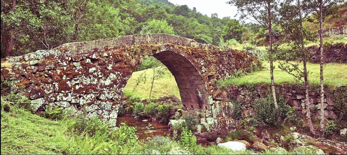
This ancient route that served those who, coming from the Castro Daire area, went down the Serra do Montemuro towards Porto Antigo, has been interpreted as an integral part of a very important Roman itinerary between two provincial capitals: Emérita Augusta (Mérida), and Bracara Augusta (Braga).
Even without exact records, it is considered a work with medieval characteristics. Interestingly, the only one on the Bestança river.
With a perfect round arch measuring around 9m in diameter; features a 2.5m wide trestle board (interior face), paved floor with large blocks and slabs, and guardrails on both sides, formed by roughly carved blocks and slabs, arranged according to the longest side.
The missing elements, mainly due to erosion, have been repaired, sometimes by the users themselves, with somewhat picturesque and rudimentary techniques.
💛💛💛💛💛

FERREIROS DE TENDAIS
41° 02' 53" N; 8° 02' 38" W
Patrimony
Church of São Pedro de Ferreiros de Tendais
Covelas baroque bridge (built in 1762)
Ruins of the Torre da Chã, which belonged to the Knights Templar, and the Pintos de Riba Bestança (from 1312).


💛💛💛💛💛💛

SANTIAGO DE PIÃES
41° 03' 26" N; 8° 09' 03" W
The church of Santiago de Piães already existed in 1087.
Patrimony:
Church of São Tiago Maior
Chapels of Santo António, São João, São Sebastião, Senhora da Conceição, Senhora do Socorro, Senhora de Cádiz and Cosconhe
Solar dos Montarroios
Póvoa, Quinta and Vista Alegre houses
Citania of Sao Fins
Sítio de Crestelo
Lugar de Castro

😍😍😍😍


VALE DE PAPAS
41.025081° N; 7.990744° W
Descrição geral:
Habitações com telhado de colmo, eira comunitária e arrecadação, espigueiros de cereais, capela, calçadas romanas, prados, gado e agropecuária, artesanato.
Vale de Papas is a serene village, located in the middle of the Montemuro mountain range. The set of granite houses, many of them still with thatched roofs, gives a special charm to this well-preserved village in the parish of Ramires, in Cinfães. Like other mountain villages, Vale de Papas lives off agriculture and pastoralism, with its animals moving daily to the pastures. Several canastros and community threshing floors and thatched houses mark the landscape of the center of the village, while all around it is the green that takes over the view and the walk is strongly recommended.
Walk the paths around the houses, on a long walk that allows close contact with nature. The entire surroundings of the village are, in fact, suitable for long walks in good company. In the center of the village, leaning against the mountains, discover several other points of interest such as the Malga stone, a large granite block, the old rubble, or the Roman road, as well as the Chapel of Vale de Papas.
On the third Sunday of July, the feast in honor of Senhora da Agonia is celebrated. The most typical activities in Vale de Papas are defoliation, hat making with straw plaits, grain husking and rye knitting.


💛💛💛💛💛

BUSTELO DA LAGE
41° 0' 10" N; 8° 0' 56" W
Bustelo, also known as Bustelo da Lage, was a Portuguese parish in the municipality of Cinfães, with an area of 6.53 km² and 115 inhabitants (2011). Its population density is 17.6 inhabitants/km².
Bustelo began as a town in the sense of a Roman agrarian background, continuing in the Middle Ages in the administrative sense, thanks to the charter, referred to above, granted to Múnio Froiaz.
In the churchyard there are two anthropomorphic tomb arches, one of them carved on one side with a double cross at the ends and in the center a human figure only outlined and placed facing forward, flanked by two crosses with fan points until they close in a circle.
In Bustelo, the threshing floors are still preserved – large, more or less flat spaces, paved with granite – where activities linked to agriculture are carried out, such as, for example, corn stripping and cereal drying. They are located in areas with good sun exposure and favorable winds. It also happens that in granite outcrops there are large slabs that are used as community threshing floors.
The threshing floors, characteristic flat spaces, paved with granite, with good sun exposure, where even today the inhabitants share agricultural tasks and it is a meeting and conviviality point.
Traditions are still very much present in everyday life and agriculture is an integral part of life in this village.
As a reflection of the popular culture of the Serra, in this locality the geographic, environmental and landscape disparities between Serra do Montemuro and Vale do Bestança are perceptible.


💛💛💛💛💛

PANCHORRA
41° 0' 50" N; 7° 58' 09" W
Its high altitude (in the parish seat it is 1088 m) makes it one of the highest villages in Portugal.
Patrimony
Parish Church of Panchorra;
Chapel of Bom Sucesso;
Chapel of São Sebastião;
Visitation Chapel;
Panchorra Bridge.
BRIDGE OF PANCHORRA
41.013979º N, 7.975075º W
A two-arched bridge, it presents a regular structure in the voussoirs [stones forming the arch] and irregular masonry [stones] in the remaining structure, which may indicate a work of local or regional masters, intended to meet the access needs of the community to their farms and forests.
Accordingly, it distances itself in importance and technique from its counterparts, built downstream, including the bridges of Ovadas, Lagariça and Nova, almost at the mouth of the river Cabrum. However, it still stands as a fine example of community infrastructure.
The crossing takes advantage of the outcrops on the riverbanks to support its pillars, upon which the horizontal deck with guards stands, providing it with the necessary sturdiness for farm vehicles and livestock to cross.
Although Panchorra is already mentioned in the Inquirições [administrative enquiries] of 1258, only in the 16th century was it separated from Ovadas, where the former religious centre of the medieval parish was located.
It became, thus, a “curato” [parish], with the Chapel of Saint Lawrence serving as the new religious centre.


Riodades (São João da Pesqueira);
Santa Comba Dão;
Santar (Nelas);
São João da Pesqueira + Trevões;
São Pedro do Sul;
Santa Comba Dão;
Santar (Nelas);
São João da Pesqueira + Trevões;
São Pedro do Sul;
São Martinho de Mouros (Resende);
São Pedro do Sul - Spa ;
Sátão;
Sernacelhe;
Tabuaço;
Tarouca + Ucanha;
Tondela;
São Pedro do Sul - Spa ;
Sátão;
Sernacelhe;
Tabuaço;
Tarouca + Ucanha;
Tondela;
Várzea - São Pedro do Sul (Spa);
Ventosa (Vouzela);
Vila Nova (Ventosa);
Vila Nova de Paiva;
VISEU;
Vouzela;
Ventosa (Vouzela);
Vila Nova (Ventosa);
Vila Nova de Paiva;
VISEU;
Vouzela;
💓💓💓💓💓
Return to mainland Portugal &
the Azores and Madeira islands

